Researchers at the Technische Universität in Wien (TU Wien) leverage Galileo High-Accuracy Service via Internet Data Distribution to enhance GNSS accuracy, inspiring young professionals to innovate.
In the field of satellite navigation, the Galileo High-Accuracy Service (HAS) has become a significant innovation, offering unparalleled accuracy for various applications. Researchers Marcus Wareyka-Glaner and Gregor Moeller from TU Wien, Department of Geodesy and Geoinformation, have been investigating Galileo HAS via Internet Data Distribution (IDD) to enhance GNSS accuracy in smartphones, highlighting its potential for driving scientific progress and fostering innovation.
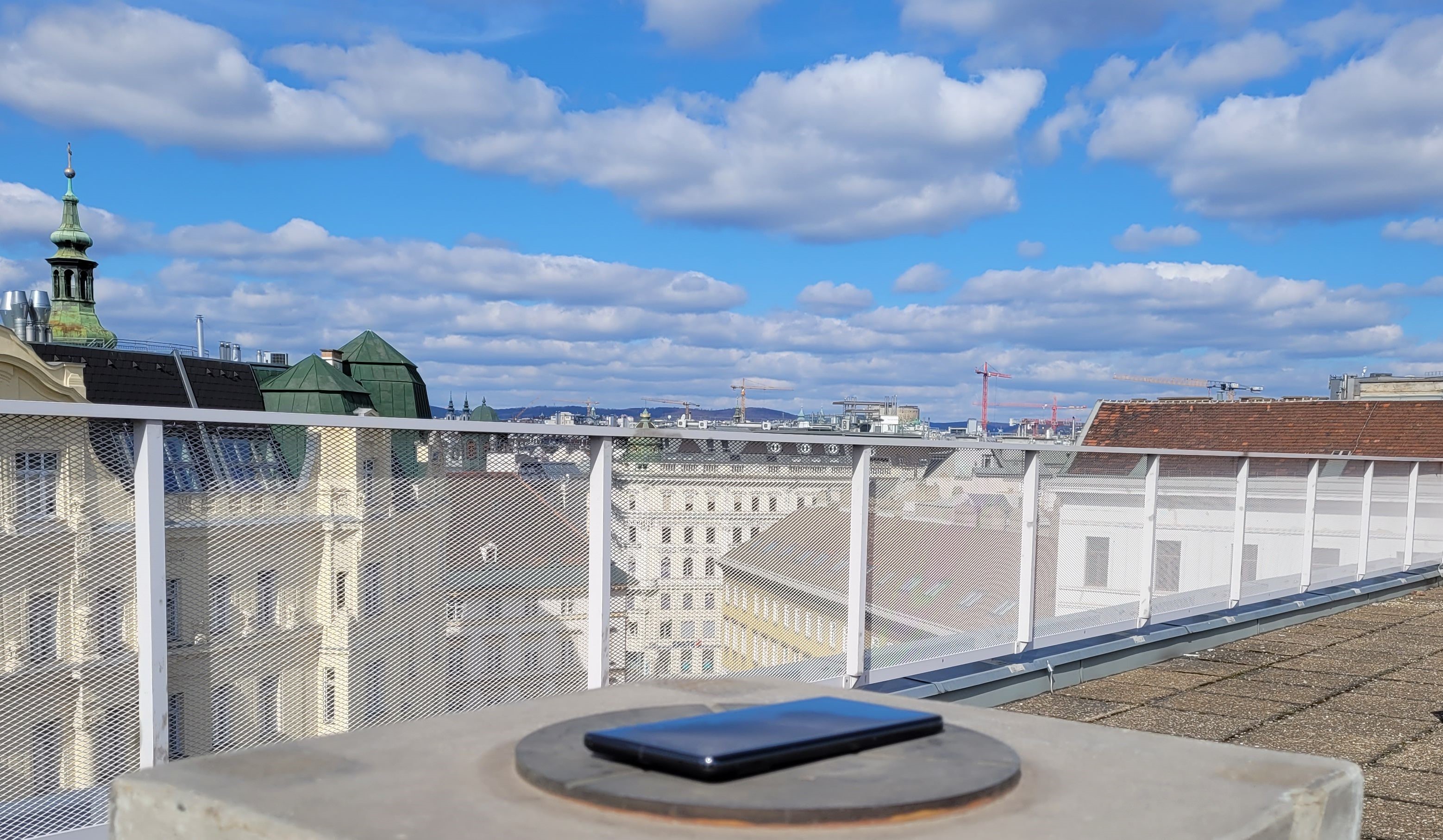
A smartphone placed on a geodetic reference point at the rooftop of TU Wien, used to record GNSS measurements for processing with Galileo HAS Service corrections to assess accuracy and performance.
Challenges of Smartphone GNSS Chips and Antennas
Smartphones are typically equipped with basic, cost-effective GNSS chips and antennas, leading to GNSS observations that are much noisier and more prone to outliers compared to those from geodetic GNSS equipment. The accuracy of these observations is often 10-100 times worse, posing a significant challenge to achieve high accuracy. As depicted in the figure below, the smartphone’s code residuals (right) exhibit more scatter and higher values compared to the geodetic receiver (left), reflecting the lower quality of its GNSS components and its less sophisticated processing capabilities.
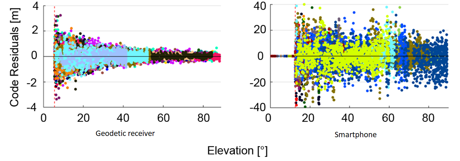
The figure shows the code residuals over elevation for a geodetic receiver (left) and smartphone (right), exemplifying these aspects.
The Role of Galileo HAS via IDD
Galileo HAS via IDD provides real-time corrections for Precise Point Positioning (PPP) over the internet, enabling decimetre-level positioning accuracy. The integration of these corrections into smartphones has the potential to achieve high-precision positioning in everyday devices.
Experiment Setup and Methodology
Marcus Wareyka-Glaner and Gregor Moeller conducted their experiments by placing smartphones on a geodetic reference point at the rooftop of TU Wien. Using a GNSS logger application they recorded GNSS measurements while simultaneously capturing Galileo HAS corrections via IDD on a computer. Subsequently, they processed the combined dataset using Precise Point Positioning (PPP) techniques for analysis. The known coordinates of the reference point allowed them to accurately assess the performance of the PPP solution, demonstrating the impact that Galileo HAS could have on a smartphone’s positioning accuracy.

Contribution of Galileo High-Accuracy Service to achieving sub-meter accuracy
The following image shows the convergence behaviour using Galileo HAS corrections in a GPS and Galileo processing. The introduced PPP approach achieves a 2D position accuracy below the one-meter level. After a convergence time of 6 minutes the median 2D position error is 84 cm.
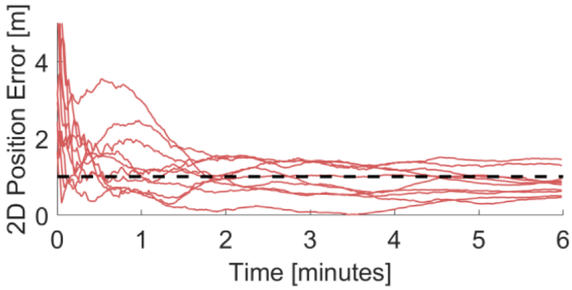
Horizontal position difference applying corrections from the Galileo HAS in a GPS & Galileo processing for a dual-frequency smartphone using code observations and phase observations.
Innovative Technical Solutions
Marcus Wareyka-Glaner, the creator and main developer of the software raPPPid used for testing and developing smartphone PPP algorithms, was able to efficiently introduce the necessary modifications to conduct their research such as the handling of high noise levels and outliers and the detection and management of cycle slips in phase measurements, among others, stabilizing the estimation of a constant float ambiguity. These innovations played a pivotal role in harnessing the recorded GNSS measurements on the phone and fully capitalizing on the Galileo HAS corrections received via IDD.
Future Applications and Research Directions
The research by Marcus Wareyka-Glaner and Gregor Moeller has the potential to revolutionize the positioning performance of smartphones and other low-cost GNSS devices. Future applications may include achieving lane-level accuracy for navigation systems and autonomous driving. Furthermore, their algorithms and insights could help use smartphone GNSS measurements to study atmospheric phenomena, such as severe rain events.
The next steps in their research involve optimizing the positioning model for kinematic applications and challenging environments, such as urban canyons. They are also planning to develop a smartphone application based on the algorithms tested.
It is just the beginning of transformative evolutions
Through the innovative use of Galileo HAS via Internet Data Distribution, Marcus Wareyka-Glaner and Gregor Moeller have achieved promising results towards reaching sub-meter GNSS accuracy in smartphones. By addressing the challenges of basic GNSS chips and antennas, developing robust technical solutions and leveraging advanced software tools, they have significantly improved smartphone accuracy. This research not only paves the way for practical applications in positioning and navigation but also highlights the transformative power of high-accuracy GNSS data in everyday technology.
Media note: This feature can be republished without charge provided the European Union Agency for the Space Programme (EUSPA) is acknowledged as the source at the top or the bottom of the story. You must request permission before you use any of the photographs on the site. If you republish, we would be grateful if you could link back to the EUSPA website (http://www.euspa.europa.eu).